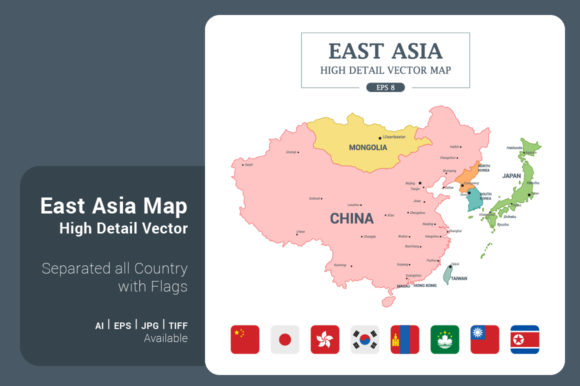
EastAsia Map Color Separated Country: A Complete Design Toolkit
Working with geographic data can often feel rigid and uninspired, but having the right assets changes the entire workflow. The EastAsia Map Color Separated Country resource is designed to bridge the gap between raw data and polished, professional visuals. This isn't just a flat image; it is a comprehensive vector illustration set that provides a high-detail view of the region in a convenient square format. With a massive resolution of 5000x5000 pixels (or 42x42 cm), it offers the flexibility needed for everything from large-scale print posters to crisp digital infographics.
The core appeal of this asset lies in its versatility and structural integrity. As a vector-based illustration, the EastAsia Map allows for infinite scalability without pixelation. Whether you are designing a presentation for a corporate boardroom or creating social media graphics for a travel blog, the visual quality remains consistent. The "Color Separated" aspect is particularly valuable for designers who need to customize the look and feel of their projects. You can easily adjust colors to match a specific brand identity or highlight specific countries for data visualization purposes.
Visual Characteristics and Design Flexibility
From a design perspective, the style of this map strikes a balance between accuracy and aesthetic appeal. It is not merely a topographical outline but a full-color, high-detail illustration. The square shape (16.5" x 16.5") makes it ideal for modern web layouts, Instagram posts, and print materials that require a balanced composition. The file formats included—such as .AI8, .EPS8, .JPG, and .TIF—ensure that it integrates seamlessly into various professional software environments, whether you are using Adobe Illustrator for detailed vector manipulation or Photoshop for raster-based editing.
For creators working on tight deadlines, the inclusion of pre-rendered assets is a significant time-saver. The package includes flags for 8 different countries in both PNG and JPG formats at various sizes (512px, 256px, 128px, and 64px). This is particularly useful for web design and application development, where quick loading times and crisp resolution on different screen densities are essential. Instead of hunting for separate icon sets, you have a cohesive visual language right out of the box.
Strategic Applications for Professionals
Understanding where to deploy the EastAsia Map Color Separated Country asset is key to maximizing its value. Here are several practical scenarios where this toolkit excels:
- Marketing and Content Creation: Bloggers and marketers can use the map to illustrate articles about trade, tourism, or cultural trends in East Asia. The high detail ensures that the graphic looks authoritative and trustworthy, which supports E-E-A-T (Experience, Expertise, Authoritativeness, and Trustworthiness) principles in content strategy.
- Business Presentations: Entrepreneurs presenting market analysis or logistics plans can use the color-separated feature to highlight specific regions of operation. This creates a clear visual hierarchy, helping the audience focus on the most critical data points.
- Educational Materials: For publishers and educators, the map serves as an excellent foundation for infographics. You can overlay text, data points, or icons to create engaging learning materials that are easy to read and visually stimulating.
- Branding and Packaging: Small business owners involved in international trade or tourism can incorporate the map into their packaging design or brand collateral. It adds a layer of sophistication and global awareness to the brand identity.
Technical Integration and Customization
One of the standout features of this asset is its "simple to customize" nature. In a professional workflow, adaptability is crucial. The vector files allow you to isolate individual countries, change stroke weights, or alter the color palette to fit a specific modern typography or design trend. For example, if your brand uses a minimalist sans serif font, you might opt for a monochromatic map style with thinner lines. Conversely, a bold, colorful map might pair better with a heavy display font for a poster.
When integrating the map into digital projects, such as website headers or mobile applications, the 5000x5000 resolution provides ample room for cropping. You can focus on a specific sub-region without losing quality. The .EPS and .AI formats are particularly useful here, as they allow for non-destructive editing. This means you can experiment with different layouts and color schemes without permanently altering the original file.
Evaluating Fit and Final Thoughts
Before incorporating any design asset, it is wise to evaluate how it fits within your broader visual system. The EastAsia Map is a distinct visual element; it should complement, not overpower, your typography and other graphics. Consider the context: Is the map the focal point of the design, or is it a supporting background element? This will dictate how you style the colors and which file format you select.
Ultimately, this resource is built for practical application. It is a tool designed to solve the common problem of needing high-quality, customizable geographic visuals. By providing a comprehensive set of files—from vector illustrations to ready-to-use flag icons—it caters to the diverse needs of designers, marketers, and business owners alike. Whether you are crafting a detailed infographic or a simple social media post, having a reliable, high-resolution map asset in your toolkit ensures that your work looks polished and professional.